Clearwater River Expedition
August 2006
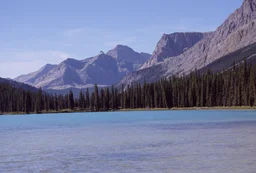
A one-hundred and twenty kilometer trek
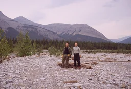
Eddie and
Scott did by foot
along the
Clearwater
River with an additional one-hundred kilometers of hitch
hiking. The journey started in
Rocky
Mountain House and finished in
Lake
Louise. For a revisit of this path see
Trial by Canoe.
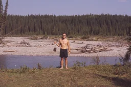
Day One
It is five o'clock in the evening on August nineteenth and the
Greyhound bus has arrived in
Rocky
Mountain House exactly when it was scheduled to arrive. There
seem to be quite a few more people on the streets than the last time
we were here. I am seeing fairly blue skies overhead, but I don't
like those black clouds on the horizon. We are going to hit the road
right away so we can get as much distance as we can in today.
Leighton said it will be difficult to hitch a ride. I am hoping it
will be as easy as it was last time we were here. We are planning to
be at the hike start location by day three.
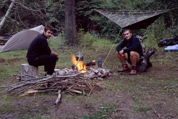
The hitchhiking sure went well today, three vehicles picked us up
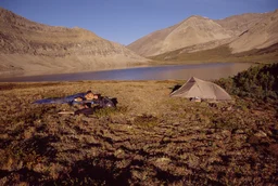
and we are camped somewhere on Prairie Creek about twenty kilometers
from our start point. Further to our luck there seems to be a camp
site set up here already with flat ground for Scotts' tent and a
fire pit ready to go. The creek is difficult to get to because the
bank is about a meter off the water, but we are managing without too
many fall ins. The first people to pick us up were a couple of
interesting guys with a real foul smelling dog who were here looking
for work. They offered to bring us the whole way in exchange for
some drugs or alcohol, but we unfortunately neglected to bring some.
The second car was a couple of what seemed to be respectable high
school kids going to a party. The third, interestingly enough, was
a couple of good looking young girls that were apparently working in
the area. We were going to ask if we could take a picture with all
of us together, but we reckoned it would be the last thing a girl
would want asked of her after she gave a ride to two strange guys
into the middle of nowhere. We're cooking up some sausage, soup and
tea for supper right now and it looks to be quite a formidable meal.
Day Two
Well, after a good breakfast of three instant oatmeal packs, we hit
the road hoping to make good time. It looks like after one day here
we already lost our spoons. I guess we'll be eating soup with forks
for the next days. After about forty-five minutes of thumbs up and
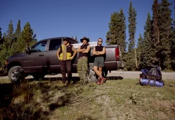
no stops, a geologist from Seattle pulled over to give us a lift.
Seems he is in the area contracted to do surveying for coal
deposits. As per his request we shan't mention his name or the
company he was working for. It seems there is an insurance issue
with picking up hitch hikers while working. He is by far the most
interesting person we have met on this journey so far; very like
minded to us in that he wished he was born a hundred years ago. His
wife is in Peru right now and seems to be quite the adventurer
herself. He gave us his name and e-mail address so we will make
sure to contact him when we get back. He went out of his way and
gave us a ride all the way to our start location at the camp site
along Elk Creek at N52° 03' 15" W115° 38' 50".
It seems we have already gotten ourselves lost. The lesson learned
is that one should not so blindly trust the maps on ones' GPS unit.
Paper maps, which we luckily brought as well, are much more
reliable. It appears that we underestimated the distance from the
camp site to the Clearwater River. We came upon Peppers Creek and
mistook it for the River. Just last year I was on the Clearwater so
how I mistook that trickle of water Peppers Creek for a river is
beyond me. Hopefully the distance we walked in the wrong direction
doesn't mess things up too much.
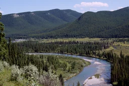
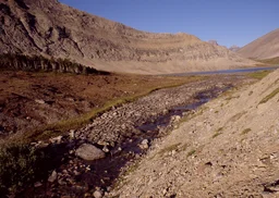
We have gotten ourselves back on track and are quite on our way
now. Our position is about eight kilometers down the Clearwater and
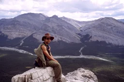
we have just passed onto an interesting obstacle. With a turn of
ill favored luck, the bank transformed into a fairly steep cliff
about four stories high. We decided the easiest thing would be to
pass over top of the ridge so here we now sit on top with quite a
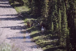
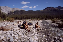
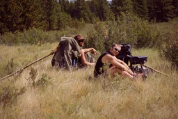
nice view. There is a group of horseback travelers
below us on the opposite side of the river.
I am assuming they just set out from the equestrian staging ground
a few kilometers east of here. Judging by the gear they have on
their pack horses it looks like they are in for quite a journey
themselves. One man is trying to say something to us but his voice
is too muffled over the distance. Good luck to you fellows. I am
pretty worn out up here, I reckon we shall set up camp once we get
to the other side of this ridge.
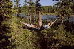
We broke camp at about three in the afternoon along the river on a
nice open spot at N52° 00' 55" W115° 42' 10". The sun is still
beaming down hot so we opted to taking a quick swim in the river
and it sure was cold. Since the day was still young I took a quick
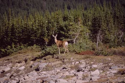
nap in the hammock only to be awakened by the sound of a
white
tailed deer rustling in the bushes upwind from us. I tried
to sneak up on her with the camera but I guess my feet aren't as
stealth as I'd hoped. She leaped away into the sunset before I had
a clear view. Time for supper now so well have a quick munch of
bannock, sausage and soup and maybe stay up to see the stars and
have some tea.
Day Three
It looks like the nice weather is sticking with us for now. We're
lunched on some flood plains wishing we had some shade. These dried
apricots are starting to grow on me. I'll have to thank my lady for
getting me to bring these. Our location is N51° 59' 10" W115° 43'
45" and I can see some rocky peaks starting to show themselves. We
should be into the mountains in just a few days. Looks like we
will make a good distance today.
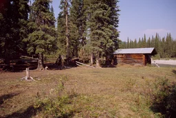
We have come about twelve kilometers and stumbled across an old
trappers cabin at N51° 57' 42" W115° 42' 28" and are going to set
up camp here. Although it looks like it hasn't been used for
trapping in quite some time, someone has adopted it as a rest spot
for equestrian travelers along the river. We've also noticed a well
used trail covered with horse tracks and what we are guessing is
modern horse caravan tracks along this part of the river. Looks
like this place sees more traffic than we originally guessed. The
trail unfortunately isn't of that great a value to us because it
constantly crosses the river to stay on the inner banks of the
bends. A cross might be easy for a horse, but it's quite difficult
for a guy carrying a seventy pound pack who doesn't want his boots
wet.
While cutting off on the trail earlier on while it was on our side
of the river, we ran into a flock of grouse and managed to snag one
for supper. Even though we hadn't planned to do any hunting this
trip, we had a hankering for some extra protein and the opportunity
was just too much to pass up. I got him with a throw from my bowie
knife. While butchering the bird using the the step on wings and
pull the feet technique it didn't come apart very well and we had
to do a little dirty work.
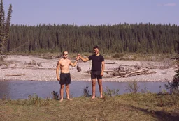
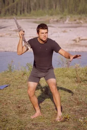
After a quick swim in the river Scott made himself an impressive
spear out of a deers' leg bone and his walking stick. He hopes to
get some supper tomorrow with it.
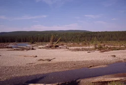
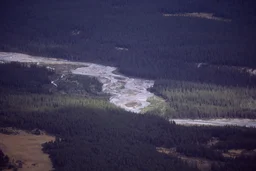
The river has brought about quite the destruction to this area. It
looks as though the river flooded quite violently this spring and
destroyed a large area of the west bank. Trees are scattered all
around and the needles on them are still green. The soil was
carried away and all that remains is a rocky wasteland. The
trappers cabin here is itself hanging over the river a foot or so.
In a year or two it will probably be swallowed by the rivers wrath
as well. I reckon my plans to build a small vacation cabin on this
river are going to need some restructuring.
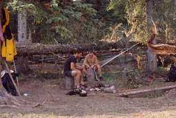
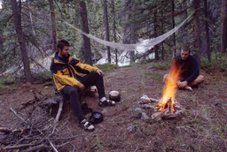
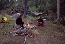
Camp here is pretty comfortable. There is a lot of flat open space
and an already made fire pit for us. The grouse is cooking in with
a pot of onion soup. My one concern is the lack of adequately
spaced trees for me to sleep in. Looks like I will be sleeping with
no shelter beneath the open stars tonight. Should be a nice view
but I hope there isn't any rain or a heavy dew tonight.
Day Four
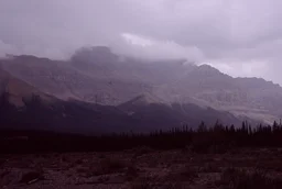
Well, there was no rain overnight, but the dew fell quite heavily.
My bag is wet and the sun is hidden behind a thick layer of
overcast clouds. I will have to try to dry my bag as best as
possible without the sun. Looks like we might see some rain
today.
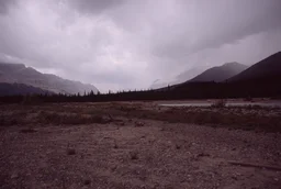
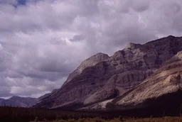
Lunch has come at N51° 54' 52" W115° 42' 17" as we have finally
reached the river after a long haul through the woods on the trail.
We have passed through the Gate of Mountains into the Ram Range and
it sure looks dreary outside. A smog has blown in from the mountains
to the west that reeks of smoke. When the wind blows you can feel a
heat that doesn't fit the day and it tells me a fire must be nearby.
I am starting to hope for a heavy rain.
Camp is set up and with scattered showers the smoke has subsided.
We are buried in the trees along the river at N51° 53' 38" W115°
42' 57" and have come about nine kilometers from morning. I think
we may have frightened some riders earlier today with a rather
awkward situation. We spotted a flock of grouse just off the path
so we dropped the packs to go get some diner. Having heard voices
coming from down the path we went to check it out only to come out
of the woods in front of a man and his daughter with large blades
drawn. He gave us the usual speech about how we must not have
enough food to complete our plans and we don't know what we are
getting into. Scott has just come back from a quick spear hunt in
the bush with a nice grouse for tonight. We'll cook it up tonight
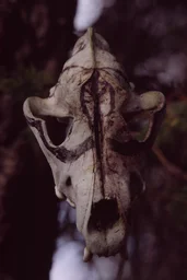
with some beef noodle soup. We've made a tribute to the River Gods
out of a coyote skull as thanks for all the grouse.
Day Five
So far the weather is has been awful today. My wish for a good rain
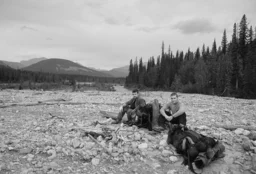
has been granted. We are taking a lunch break at in the rocky flood
plains just after Forbidden Creek at N51° 53' 14" W115° 44' 21".
We've only come about two kilometers since morning for we made the
foolish mistake of crossing the river. I unfortunately forgot to
bring my sandals (one of the most important things to have) so I
had to try and cross the river with bare feet. I would have say
that crossing a rocky river bare foot with a heavy load is one of
the worst things I have ever done in my life. I've now got a gash
on my left foot from a sharp rock and I sure hope I don't get a
worm of some sort through it. We have aquired a liking for a few
berries along the trail: Rose Hips, Bear Berries and Red Cherries.
The Red Cherries are a bit tart for my liking, but Scott has taken
to them.
We have crossed back over to the west side of the river. Crossing
to the east side was a mistake to begin with. The lesson learned is
pick a side of the river and stick with it. You only notice the
other side of the river when the side your on becomes difficult. We
didn't bother to take our boots off this time. Right now we are by
the fire trying to dry our boots and socks off. It is still raining
but the sleeping hammock is doing quite well in the wet weather. If
you set the hammock up high enough, you get a good little shelter
to work underneath. It's light and compact and the only problem I
have with it is that on a very humid night moisture does start
beading on the inside of it. Were camped on a campsite at N51° 52'
36" W115° 47' 26" that looks like it has been used for more
equestrian stopovers. There is an old tent here but there isn't
anybody around using it. All in all we only moved about five
kilometers today.
Day Six
The clouds have vanished and the sun is shining. I'll have to get
some quick dry time under the sun for my gear before we pack up and
go. It looks as though today will be a good day. I am hoping we
travel well today.
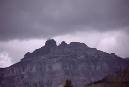
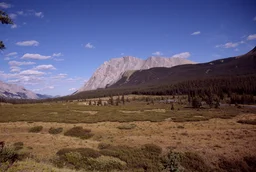
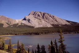
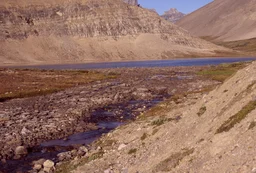
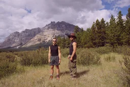
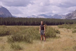
We have hit the Harrison Flats at N51° 51' 48" W115° 51' 47" and
decided to stop here for lunch. It is an interesting area. I am not
entirely sure why this large area remains treeless. Perhaps
flooding occurs here in
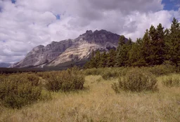
the spring time, or maybe the topsoil layer is too thin. A mountain
with a fascinating summit is in the distance. According to the map
it is yet to have received a name. The top has the look of an evil
fortress of sorts so I thereby dub it Alcazar Mountain.
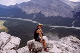
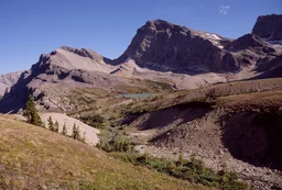
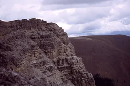
This entry comes from the top of the newly named Alcazar Mountain.
It seems that our path led us to the base of the Mountain. We
figured the Mountain had led us there, we might as well climb
it.
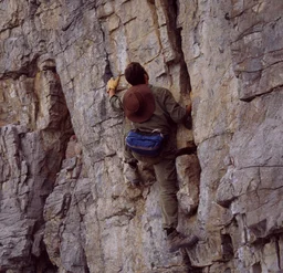
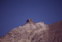
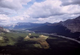
The ascent had it's rough spots but we pulled ourselves to the top
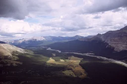
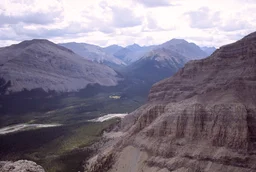
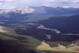
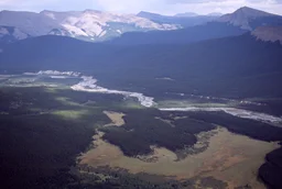
to find quite a view waiting for us. The valley of the Clearwater
has a majestic look as it's multiple braids wind and contort into
each other; blazing new paths to carry themselves downstream.
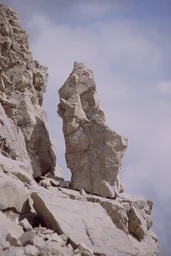
On the Mountain side sits an eye catching stone monument. It is a
monolith with a pointed tip that stands upon a slight incline. I
feel hail on my hat, and I hear it on the rock. Perhaps we weren't
meant to climb this mountain.
The road down looks more treacherous than it seemed on the way up.
I hope I get to make another entry.
Despite the climb we've come just under ten kilometers from this
morning and camped in a spot with some rather dense foliage at N51°
51' 27" W115° 54' 50". The place needed a little grounds keeping
before we could get anything set up, but it is pretty cozy right
now.
It seems the sky has decided to start dumping the rest of its'
moisture on us tonight as a very strong rain storm has picked up.
We were luckily able to get our gear set up before the onslaught.
The rain is so thick that I can no longer see the mountains. Scott
can't stand this weather as he needs to sleep in his clothes, but I
don't mind it. My sleeping bag is warm enough that I can sleep with
just some briefs in the hammock. We've managed to keep a decent
fire going despite the rain and our supper shan't be short changed
because of some dampness. I however sure don't look forward to
seeing the state of things tomorrow.
Day Seven
It is quite late in the morning right now as it took quite a long
time to get a fire going. It looks like the clouds completely
emptied themselves last night. Everything was absolutely drenched
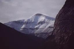
this morning and some peaks were capped with snow. The sun shone
through but getting a fire going was very frustrating. Scott gave
up earlier, but I just couldn't live without having my hot bowl of
oatmeal for breakfast. After much cursing and throwing of wood into
the forest, fire burst forward and water was eventually boiling. We
hope to pass into
Banff
National Park and make Trident Lake today. It will be quite
a trek but today seems to promise just the weather we need for
it.
We are lunching on a unnamed tributary of the Clearwater just a
kilometer or so shy from the Banff border. The water was so
refreshing looking that we have decided to forgo use of the water
filter and just drink straight out of the creek. It sure is
satisfying after a long walk on a hot day. I hope we don't get
sick. I am of the opinion that fresh water above the altitude lines
of civilization on the Clearwater is safe to drink.
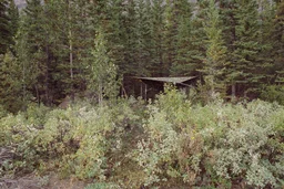
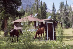
We've found an interesting cabin way out in the middle of nowhere.
It looks to be an old ranger cabin beefed up with solar panels and
modern heating. There is nobody here except a couple of horses with
bells who seem quite healthy and content. It is right off
Indianhead Creek in
Banff
National Park so I'm guessing it is Indianhead Cabin. I am
curious how often this cabin actually sees a park ranger these
days. With the restructuring and cutbacks in the parks I bet there
aren't any rangers in this area anymore.
We have entered into the transition area that goes from forest to
alpine plains. The Clearwater seems to have calmed down and isn't
the mess of braids that it once was. It is very quiet here without
the chirping of birds, creaking of trees and rustling of
leaves.
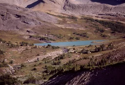
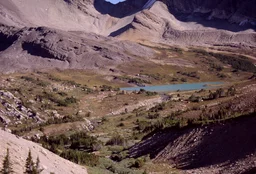
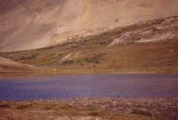
Trident Lake is quite a sight for sore eyes. We've waited for quite
some time to see this lake. The lake is basically when the
Clearwater matures into a river. It was dubbed Trident Lake because
it is fed in a cross formation by three creeks: the Clearwater,
Martin Creek and Roaring Creek. This is the last time we will see
the Clearwater as a canoe navigable river. We'll walk a bit longer
until we find a good camp spot.
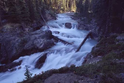
We have come across a powerful waterfall along Martin Creek. This
section of the Creek connects Trident Lake with Martin Lake over a
significant elevation change.
The lakes are only about one hundred meters apart, but Martin Lake
is about fifty meters higher in elevation.
Camp is set up along side the waterfall at N51° 47'
50" W116° 07' 40". All in all we traveled about eighteen kilometers
today. We are going to aim for the Devon Lakes on Clearwater Pass
tomorrow. This area has not been scrounged for firewood in a very
long time. There are dead branches attached to trees that have been
there so long that wood has grown over top of them.
There is a little spot along the waterfall that we can collect
water from but it sure would be awful to fall in. Some of the trees
around here are sure twisted and deformed.
Day Eight
We are taking a lunch right now at N51° 45' 29" W116° 10' 02" with
the majestic Mount Harris to our right and a baby Clearwater River
to the left. We saw Martin Lake first thing today and unfortunately
had to cross Martin Creek bare foot. We weren't sick this morning
and have taken to drinking all of our water unfiltered and
unboiled.
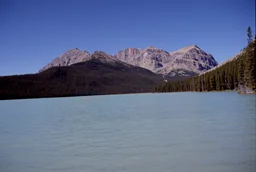
We passed by Clearwater Lake mid-morning and ran into some riders
who set out a few days ago as well. I think they may have been the
same group we spotted on day two. One interesting character was a
retired fellow named Allan who is native to
Sherwood
Park like myself. Seems he had been working in a Christian
mission hospital in Pakistan until recent years. It is always
interesting people you meet out here.
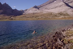
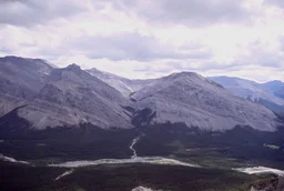
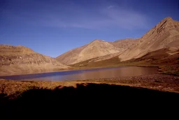
I am sitting on a rock in front of the big Devon Lake right now.
Our camp is set up at N51° 43' 46" W116° 14' 52" about twenty-three
hundred meters above sea level, fourteen kilometers away from our
position this morning.
The ascent into the pass carried a vicious incline with it but we
still made good time. The view up here on Clearwater Pass is really
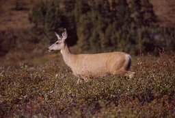
amazing. Scott spotted a
mule deer doe
up here and she was pleased to pose in front of the camera for me.
I chased her around for a half hour or so trying to stay between
her and the sun. She eventually got bored and bounced away. The
Devon Lakes almost look like some sort of fantasy world.
It is a rolling green pasture with scattered rocks protruding from
the ground. The trees look normal from a distance but up close you
realize they are basically bonsais. They only come up to our
shoulders but everything on them is of a proportionally normal
size. Since I can't use my hammock tonight it looks like I will be
sleeping beneath the open stars.
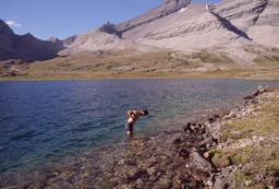
We tried out the waters for a swim. Well, I swam but Scott just did
a knee high walk through. The sun was very hot while it was out but
once it set the temperature dropped like a rock. I hope it doesn't
get too cold tonight. The wind has really picked up so I've propped
the tarp of my hammock over my sleeping bag to keep the wind from
penetrating it. This fire is sure burning fast with this breeze. It
is like a blast furnace.
Day Nine
I was awoken by the sun early today. The air has a nip to it but
the sun is hot. It looks like it dipped below freezing last night
as there is ice on my sleeping bag and the ground is frozen. I
guess that explains the mini trees. I had trouble sleeping last
night as the stars were brighter than I have ever seen in my life.
I assume it is a symptom of a clear night at a high altitude. Every
time I opened my eyes to roll over I was captivated by the heavens
above me for what seemed like hours. While packing up our gear this
morning Scott realized that his wallet which had the e-mail address
of the geologist from Seattle has gone astray. Maybe when I put
this on the net he will somehow stumble across it.
We will try to burn off as much distance today as possible since
this expedition was meant to explore the Clearwater River. We are
now at the very beginning of it and this trickle coming from the
Big Devon sure doesn't carry the power and wrath it does
downstream. The sun is good right now for a picture of the big
Devon Lake so I'll do that and I guess we'll say goodbye to the
River.
There is an interesting rock formation at the top of Clearwater
Mountain that looks like it would make a good middle age watch
tower.
We are having lunch at the highest altitude point we will hit. It is
over twenty-four hundred meters and from here on we go downhill. Our
coordinates are N51° '42 "06 W116° '15 "22. We were surprised as to
the lack of information signs or properly kept trails here in the
park so far. We shall see how they are further up.
It is eight in the evening and we have walked for nine hours in
total now. We've covered twenty-seven kilometers today and are
completely destroyed. Our location is N51° 34' 22" W116° 08' 43" at
some apparent "historic site". It is an old ranger cabin that must
be historic because rangers don't actually come out here anymore. We
had to cross Pipestone Creek and got our boots wet again; I don't
really care anymore since we are almost at
Lake
Louise. We passed a big fat grouse while walking today, it
sure looked tasty but we couldn't take it. I wish we weren't in a
park. What trails there are here seem to have fallen into disuse. I
guess why would somebody pay exorbitant fees to hike here when they
could just go outside the park for lands that are just as remote.
It seems that now all the money and resources of the park department
go towards up keeping areas frequented by international tourists on
tour buses. Not a cent for the back country. We should be in
Lake
Louise tomorrow evening.
Day Ten
We are laying on the floor of the staircase to a bar in
Lake
Louise. We made it to town at about five in the afternoon;
just missing the four-thirty bus. We now have to wait here until
three in the morning for the next bus. We had some good burgers from
the bar earlier but now I am just dying of boredom. We did about
seventeen kilometers today.
I'm home now and going to take a shower and go to bed... adios.